Remnants of Dolly bound for Florida while Tropical Storm Edouard could form in Gulf, NHC says
Published in News & Features
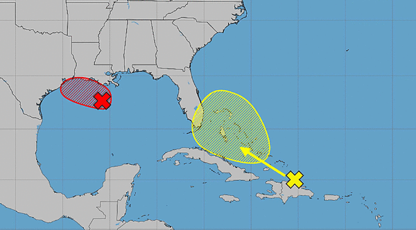
ORLANDO, Fla. — The National Hurricane Center on Monday said a short-lived tropical depression or storm could form in the Gulf while the remnants of Tropical Storm Dolly are headed to Florida.
As of the NHC’s 8 a.m. tropical outlook, what had been Dolly, that was only a tropical storm for one day last week, is now just a surface trough of low pressure producing a disorganized area of showers and thunderstorms stretching from near Hispaniola eastward to the northern Leeward Islands.
“Redevelopment, if any, would be slow to occur during the next few days as the system encounters generally unfavorable upper-level winds while moving quickly west-northwestward at 20 to 25 mph,” forecasters said. “Regardless, the system could bring locally heavy rains and gusty winds to portions of the Leeward Islands, the Virgin Islands, Puerto Rico, Hispaniola, and the Bahamas during the next couple of days.”
The forecast models then bring it near the Florida peninsula and into the Gulf, although it may only just a simple rain event.
“There is potential for a tropical wave currently near Puerto Rico (the remnants of Tropical Storm Dolly) to pass near Central Florida, which combined with the onshore flow and high moisture, could increase the potential for heavy rainfall impacts,” said the National Weather Service in Melbourne.
Local rainfall totals could top 4 inches and the Weather Prediction Center says all of Florida would have a marginal risk for excessive rainfall on Thursday.
“Models continue to show swell from back when Dolly was a tropical storm arriving midweek, which could increase the rip current risk at the beaches,” the NWS stated.
The NHC dropped its forecast chances it could redevelop to just 10% in the next seven days.
Meanwhile, already in the Gulf about 100 miles south of the coast of southern Louisiana is an area of low pressure with a small but concentrated area of showers and thunderstorms showing some signs of organization.
“Additional development is expected as the low moves slowly west-northwestward, and a short-lived tropical depression or tropical storm is likely to form before the system reaches the upper Texas or southwestern Louisiana coasts on Tuesday,” forecasters said.
If it becomes strong enough, it could develop into Tropical Storm Edouard.
“Interests along the southwestern Louisiana and Upper Texas coasts should monitor the progress of this system, as tropical storm watches or warnings could be required for portions of the area later today,” forecasters said. “Regardless of development, this system is expected to bring locally heavy rainfall to portions of the upper Texas andsouthwestern Louisiana coasts during the next couple of days.”
An Air Force Reserve reconnaissance aircraft is slated to fly out to the system later Monday morning.
The NHC gave it a 70% chance to develop in the next two to seven days.
Dolly had become the fourth named storm after tropical storms Arthur, Bertha and Cristobal.
Hurricane season began June 1 and runs through Nov. 30, but the height of hurricane season runs from mid-August through mid-October.
The National Oceanic and Atmospheric Administration earlier this month updated its seasonal forecast and now expects between seven and 13 named storms this year. Of those, two to six would become hurricanes. It also predicted that there might not be any major hurricanes this year, or at most two.
Already, 2026 was forecast to have lower-than-average storm generation, and that has been reduced even further with the latest forecasts from the NOAA and other weather groups.
An average year would see 14 named storms and seven hurricanes, with three of those growing to Category 3 strength or higher.
------------
©2026 Orlando Sentinel. Visit at orlandosentinel.com. Distributed by Tribune Content Agency, LLC.






Comments