Tropical Storm Isaias intensifies, forecast to threaten Florida as Category 2 hurricane
Published in News & Features
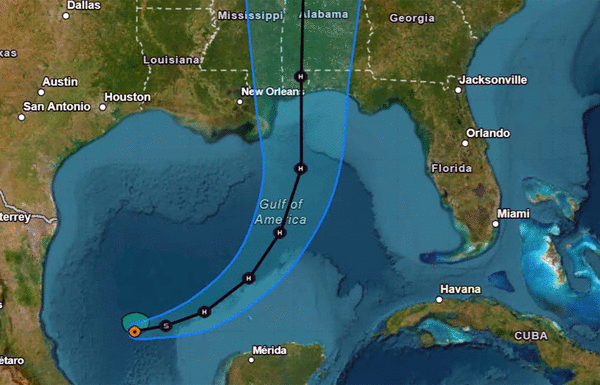
ORLANDO, Fla. — Tropical Storm Isaias formed Wednesday morning with the National Hurricane Center forecasting it to intensify close to a Category 3 storm before bearing down on the Gulf coast and threatening Florida.
As of the NHC’s 5 p.m. advisory, the center of Isaias was located about 2525 miles west-northwest of Progreso, Mexico and 500 miles south-southwest of the mouth of the Mississippi River moving east-northeast at 8 mph with maximum sustained winds of 65 mph.
“Isaias is expected to strengthen and be a strong hurricane when it approaches the northern Gulf Coast on Friday,” said NHC senior hurricane specialist Eric Blake. “The risk of damaging hurricane-force winds is increasing over portions of the Florida Panhandle, southern Alabama, and southern Mississippi.”
A hurricane watch was in effect for Bay St. Louis, Louisiana to Indian Pass, Florida and tropical storm watch from Indian Pass east to the Aucilla River and west of Bay St. Louis to the Jefferson/Plaquemines Parish line. A storm surge watch was also issued from the mouth of the Mississippi River to Yankeetown, Florida.
Tropical-storm-force winds extend out 60 miles from its center.
The system had formed as Tropical Depression Nine on Tuesday but is forecast to grow into the Atlantic season’s first hurricane, which would end the longest stretch without a hurricane since satellite tracking began 60 years ago.
The system is forecast to turn to the northeast and north on Thursday approaching the U.S. northern Gulf Coast on Friday night.
The projected path has shifted east to more threaten Florida and the NHC warns that an expanded wind field could spread hundreds of miles from its center especially threatening land falling to the east of wherever it makes landfall.
The NHC forecast calls for it to become a Category 1 hurricane by Thursday morning and strengthen to Category 2 with 110 mph sustained winds, just shy of Category 3 status, on Friday morning.
Landfall is not expected until late Friday or early Saturday, and its intensity is forecast to drop some.
“Vertical wind shear then increases quite dramatically in the final 24 hours before the cyclone reaches the northern Gulf coast, though it is looking more likely that Isaias will be a significant hurricane when it reaches the coast,” said NHC senior hurricane specialist Philippe Papin. “Near landfall, Isaias will also be interacting with the short-wave trough, likely leading to an expanding wind field.”
The system may be compact at first, it’s expected to grow in size.
Also of concern is rainfall, with some areas expected to get up to 10 inches along the central Gulf Coast extending from southeastern Louisiana east to the Florida Panhandle, bringing a threat of flash and urban flooding as well as some isolated river flooding. An additional 1-3 inches with amounts up to 5 inches could fall across much of the southeast as far north as the Tennessee Valley and the Carolinas.
Gov. Ron DeSantis on Tuesday issued an executive order declaring a state of emergency for 25 Florida counties in preparation for the storm.
“This order will allow the Florida Division of Emergency Management to stage critical preparedness resources and ensure Florida is ready to respond,” DeSantis said in a news release. “Floridians should take this time to get disaster plans in place and ensure their hurricane supply kit is stocked.”
Counties under the state of emergency are Baker, Bay, Calhoun, Columbia, Dixie, Escambia, Franklin, Gadsden, Gilchrist, Gulf, Hamilton, Holmes, Jackson, Jefferson, Lafayette, Leon, Liberty, Madison, Okaloosa, Santa Rosa, Suwannee, Taylor, Walton, Wakulla and Washington.
AccuWeather hurricane expert Nicholas Arman said the system has been organizing faster than expected.
“The environment around it is becoming increasingly favorable for strengthening,” he said. “The warm waters in the Gulf will provide plenty of fuel, and winds high in the atmosphere are lining up in a way that could help the storm strengthen more efficiently.”
The hurricane season had previously seen the formation of tropical storms Arthur, Bertha, Cristobal, Dolly, Edouard, Fay, Gonzalo and Hanna.
For the first time in 60 years, however, none has developed into a hurricane in the Atlantic with less than two months left in the season.
Hurricane season began June 1 and runs through Nov. 30, but the height of hurricane season runs from mid-August through mid-October.
The reason for the lack of hurricanes has been an extremely strong El Niño weather pattern, which is warming surface temperatures in the Pacific Ocean. This generates wind shear preventing storms from strengthening in the Atlantic.
Sammy Hadi, a lead meteorologist with the National Weather Service in Miami, told the South Florida Sun Sentinel last week that the “top of these storms that are developing are being blown off.”
The National Oceanic and Atmospheric Administration in August had updated its seasonal forecast to expect between seven and 13 named storms this year. Of those, two to six would become hurricanes. It also predicted that there might not be any major hurricanes this year, or at most two.
Already, 2026 was forecast to have lower-than-average storm generation, and that has been reduced even further with the latest forecasts from the NOAA and other weather groups.
An average year would see 14 named storms and seven hurricanes, with three of those growing to Category 3 strength or higher.
----------
©2026 Orlando Sentinel. Visit at orlandosentinel.com. Distributed by Tribune Content Agency, LLC.






Comments