El Niño: Which Northern California places are most at risk this winter?
Published in News & Features
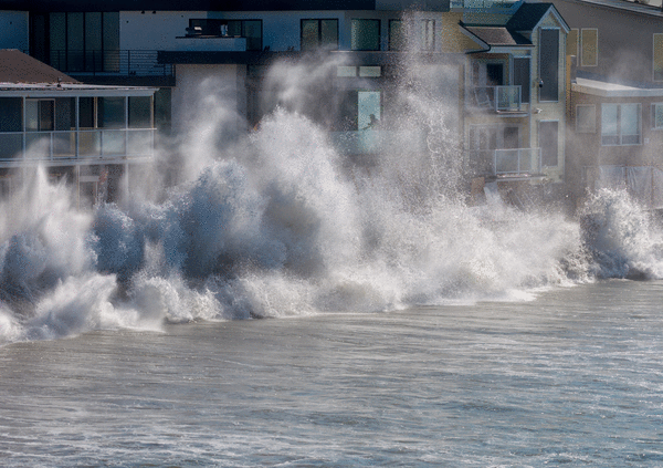
By now, most Northern Californians know that there are historically strong El Niño conditions in the Pacific Ocean which are increasing the chances for a rough and very wet winter.
But some places have more risk than others. Low-lying coastal and bayfront areas — including the beaches at Santa Cruz, the eastern approach to the Bay Bridge, Alviso in San Jose and the runways at San Francisco and Oakland airports — are particularly vulnerable to floods and damage this winter, according to a new report from UC Davis.
Sea levels of 2 to 3 feet higher than normal this winter due to El Niño conditions, on top of a high tide during a big storm, could flood roads, wreck piers and harbors, erode away beaches and damage homes in low-lying areas, along with putting wildlife habitat underwater, said Fraser Shilling, the author of the study, and director of the Road Ecology Center at the UC Davis Institute of Transportation Studies.
“Whether you are an endangered species living in a marsh, a commuter on a Bay Area highway or own a home on the shore, this winter has the risk of being the most catastrophic in recent history,” Shilling said. “My center and others have been sounding the alarm on this issue for over a decade.”
According to his report, which used GIS maps to analyze sea level rise along California’s shoreline, areas that are particularly vulnerable to coastal flooding this winter in Northern California are:
–San Luis Obispo County beaches and roadways, such as Avila and Pismo Beach
–The Elkhorn Slough area, including Moss Landing, in Monterey County
–Santa Cruz County beaches, including Rio Del Mar, the Main Beach in Santa Cruz, and West Cliff Drive and the Santa Cruz Wharf, both of which were damaged in storms in 2024
–San Francisco International Airport
– South Bay communities along the edge of San Francisco Bay, particularly Alviso.
–Oakland’s airport and the eastern approach to the Bay Bridge
–Highway 101 in Corte Madera
–Highway 37, which runs along the North Bay from Vallejo to Novato
–Stinson Beach oceanfront houses
–Roads, fields and marshes around Humboldt Bay in Humboldt County
There’s not much those areas can do now except emergency planning, Shilling said. But in the long term, federal and state agencies need to be committing billions to reduce flood risk as sea levels continue to rise from climate change.
Gary Griggs, a professor emeritus of Earth and Planetary Sciences at UC-Santa Cruz and one of the state’s experts on coastal erosion, agreed. He said this winter is shaping up to be similar to 1982-83 and 1997-98 when there were soaking storms.
“The higher the sea level and the bigger the waves, the more erosion we can expect,” Griggs said. “California’s population exploded after World War II. We developed on the beaches, on the bluffs and on the cliffs. That was during a pretty calm weather cycle. But we started to see in the 1980s there were consequences to that.”
The riskiest times this winter will come during Thanksgiving, Christmas and Martin Luther King Jr. weekend, Griggs said, when naturally occurring King Tides will be present.
“You can put out sandbags. You can clean out the storm drains,” he said. “But that’s about it at this point. The time to do something was 50 years ago. I wish there was a magic solution. But there’s no silver bullet.”
Heavy storms in recent years have caused major damage to the Pacifica Pier, the Santa Cruz Wharf and the Capitola Wharf. They have sent waves smashing into restaurants in Capitola Village and destroyed the pier at Seacliff State Beach. In recent weeks, big waves from remnant hurricanes, made stronger by warm waters off the Mexican and Southern California coasts, have damaged dozens of oceanfront homes in Long Beach, Dana Point, Malibu and other Southern California areas.
On Oct. 8, scientists at NOAA, the National Oceanic and Atmospheric Administration, said there is a 100% chance of a strong El Niño being present from now through March. NOAA said there is an 83% probability that it will rank as the strongest in history since modern records began in 1950, up from 69% two months ago.
El Niño conditions naturally occur every two to seven years when ocean waters along the equator off Peru become warmer than normal due to shifts in trade winds and changes in the upwelling of cold water. The warmer waters affect weather patterns across the globe, causing more rain than normal in some parts of the world and severe droughts in others.
Currently, surface waters in the Pacific Ocean along the equator are hotter than ever recorded for this time of year, roughly 5.8 degrees warmer than average.
El Niño events last for months and can often change the movement of the jet stream, pumping heat and moisture into the atmosphere and creating conditions that allow more winter storms to come to California, particularly Southern California — but also sometimes soaking the Bay Area and Sierra Nevada.
Although El Niño events do not guarantee wet winters in California, they increase the chances. To be sure, they occasionally fizzle out, as in 2015-16. But some of California’s wettest winters, including 1982-83 and 1997-98, have occurred during strong El Niño winters.
Supercomputer models from Europe’s main weather-forecasting center this month showed that on average, 165% of normal rainfall is expected for Northern California from January to March. Over the same period, 194% of normal rainfall is expected for Central California, and 226% of normal rainfall for Southern California.
Crews from Caltrans are already working to improve safety in one of the high-risk areas.
They plan to close Highway 37 in the North Bay this weekend from Friday at 10 pm to Monday at 5 am in both directions to pour concrete and asphalt to raise roughly 1,300 feet of the roadway, which is prone to flooding from San Pablo Bay in big storms, by up to 3 feet higher to prepare for this winter.
Last month, Gov. Gavin Newsom declared a preemptive state of emergency for El Niño. The declaration fast-tracks permits for flood protection projects and allows state agencies to obtain emergency supplies without the usual competitive bidding process.
Following suit, on Tuesday the Santa Clara Valley Water District, based in San Jose, declared a local state of emergency for Santa Clara County. And, on Wednesday, the San Mateo County Board of Supervisors did the same thing for San Mateo County.
Typically, winter rains begin in earnest after Thanksgiving.
“Roads may be closed, power may go out and people may find themselves cut off and isolated for periods of time,” said San Mateo County Supervisor Ray Mueller, whose district includes the San Mateo County coast. “We want residents to think now about and prepare for what they’ll need if that happens.”
Coastal flooding is different than inland flooding. Flooding on rivers and creeks, which has occurred during wet winters in places like Coyote Creek in San Jose, the Sacramento River in the Central Valley and the Russian River at Guerneville over the years, is heavily dependent on timing, said Jan Null, a meteorologist with Golden Gate Weather Services.
“If you have double the normal amount of rain over a winter but it is spread out, that’s different from the storms coming close together,” Null said. “The biggest factor for inland flood risk is when you have back-to-back-to-back storms or a single big atmospheric river system that sits over you for an extended period of time.”
_____
©2026 MediaNews Group, Inc. Visit at mercurynews.com. Distributed by Tribune Content Agency, LLC.






Comments