2 more tropical depressions likely as Hurricane Gabrielle targets Azores, NHC says
Published in Weather News

ORLANDO, Fla. – The National Hurricane Center on Wednesday increased the odds of two new tropical depressions to form in the Atlantic including one that could hit the Bahamas while also issuing a hurricane warning for the Azores for approaching Hurricane Gabrielle.
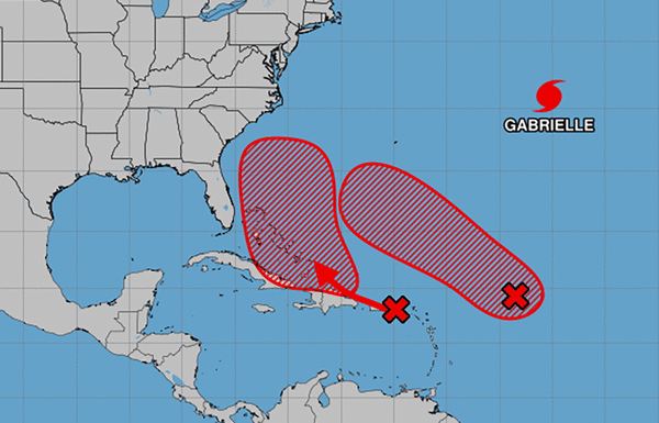
As of the NHC’s 8 a.m. tropical outlook, the closest of the systems to Florida was a tropical wave labeled Invest 94L that has been producing stormy conditions across the Caribbean’s Windward and Leeward Islands.
The tropical wave has moved into the northeastern Caribbean Sea moving west-northwest at 15 to 20 mph forecast to dump heavy rains and bring gusty winds into Puerto Rico and the Virgin Islands through Wednesday with conditions worsening over the Dominican Republic by Wednesday night.
“The system is then expected to slow down and turn northwestward when it reaches the southwestern Atlantic late this week,” forecasters said. “Environmental conditions are forecast to be more conducive for development in a few days, and a tropical depression is likely to form when the disturbance is in the vicinity of the Bahamas.”
An Air Force Hurricane Hunter aircraft is scheduled to perform a system survey Wednesday afternoon.
The NHC warned interests in the Virgin Islands, Puerto Rico, the Turks and Caicos Islands and the Bahamas should monitor the system’s progress.
Forecasters gave it a 30% chance to develop in the next two days, and 80% in the next seven.
The National Weather Service in Melbourne said it’s too early to tell if the system will be any threat to Florida aside from poor beach and boating conditions.
“The tropics are becoming more active with multiple disturbances to monitor,” the NWS stated. “It is a good reminder that we are in the peak of hurricane season and to have an emergency plan in place. Residents and visitors should continue to monitor the forecast for updates.”
The second tropical wave with an elongated area of low pressure labeled Invest 93L has a higher chance to develop and is located in the central tropical Atlantic several hundred miles east of the Leeward Islands with shower and thunderstorm activity that continued to become more organized.
“Environmental conditions are forecast to be favorable for further development, and a tropical depression is likely to form later today or Thursday while the system moves west-northwestward to northwestward into the western tropical Atlantic, well north of the Leeward Islands.” forecasters said.
The NHC gave it a 90% chance to develop in the next two days and 90% in the next seven.
If either tropical wave were to grow into a named storm, it could become Tropical Storm Humberto leaving Imelda as the next name on the 2025 Atlantic hurricane list.
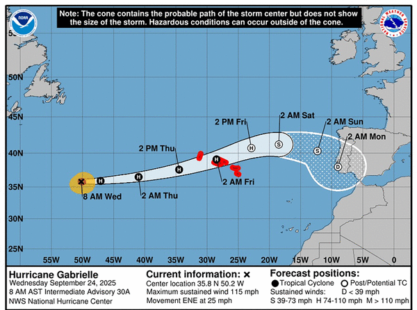
As for Hurricane Gabrielle, its forecast path has prompted a hurricane warning for the Azores.
As of the NHC’s 5 a.m. advisory, the storm still had 115 mph sustained winds, making it a Category 3 hurricane located about 1,360 miles west of the Azores headed east-northeast at 25 mph.
Hurricane-force winds extend out 45 miles while tropical-storm-force winds extend out 140 miles from its center.
“On the forecast track, the center of Gabrielle will approach the Azores during the day on Thursday, and move across the island chain Thursday night into Friday,” forecasters said. “Steady weakening is expected during thenext couple of days, but Gabrielle is still expected to be a hurricane when it passes through the Azores.”
The system is projected to bring dangerous storm surge and wind to the islands as well as 3-5 inches of rain.
The NHC also warned swells from the system will continue to slam into Bermuda and the U.S. East Coast from North Carolina northward, including Atlantic Canada, with potential life-threatening surf and rip conditions.
The climatological peak of the Atlantic hurricane season was on Sept. 10, but 60% of annual activity has historically happened after this date, the NHC stated.
The only other hurricane this season had been Hurricane Erin, which grew into a massive Category 5 system with 160 mph winds but remained in the Atlantic without making landfall.
The National Oceanic and Atmospheric Administration in early August updated its season forecast to call for 13-18 named storms this year, of which five to nine would grow into hurricanes. Two to five of those would develop into major hurricanes of Category 3 or higher.
Hurricane season runs from June 1 to Nov. 30.
-----------------
©2025 Orlando Sentinel. Visit at orlandosentinel.com. Distributed by Tribune Content Agency, LLC.


Comments