Swath of Florida coast under tropical storm watch from soon-to-be Imelda
Published in Weather News
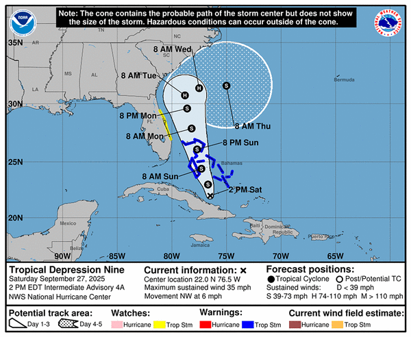
MIAMI — A stretch of the Florida coast from Martin County to Volusia County was placed under a tropical storm watch Saturday morning — though the strongest winds of soon-to-be Tropical Storm Imelda were expected to stay well offshore.
The long-term forecast for the system, which reached depression strength and was expected to become a tropical storm Saturday evening or early Sunday, remained tricky.
The predicted path for the next few days would keep the system’s core off the Florida coast as it tracks north. But forecasters now believe it could avoid a direct landfall as it nears the Carolinas and instead be yanked out to sea, likely by the strong atmospheric pull of now Category 5 Hurricane Humberto.
That would still mean heavy rain for the Carolinas, and the forecast that far out remains uncertain, meaning the path could shift back to favoring landfall or a stalled out storm just off the coast dumping rain on a state that suffered devastating flooding during Hurricane Helene last year.
It could also mean tropical storm gusts and pounding surf for much of the east-central Florida coast — the reason why the National Hurricane Center put the area from Martin to Volusia under a tropical storm watch, including the waters offshore of Palm Beach County. That means worsening conditions could be felt in the next 48 hours.
As for South Florida, the Miami office of the National Weather Service said early Saturday that the “most likely scenario” is that surf and sea conditions begin to go downhill starting Sunday, making the coast less safe for boaters and swimmers for a few days.
A “less likely scenario,” the NWS said, is that outer fringes of the system may blow bands of rain and gusty wind across South Florida early next week as the system passes by.
Still, experts urge coastal Floridians to be prepared. Craig Setzer, chief meteorologist for Royal Caribbean, posted on X Saturday that it’s a good time to prepare for some higher than usual winds.
“The trend through the Bahamas is farther west meaning, South Florida will feel wind & squalls increase on Sunday. It’s not a bad idea to secure lose outdoor items, especially along the east Florida coast, to prevent them from blowing around,” he wrote.
As of the 5 p.m. update, it’s still expected to strengthen into Tropical Storm Imelda by early Sunday, right before it crosses the Bahamas, much of which remains under a tropical storm warning.
The system is on track to pass Florida Sunday evening through Tuesday morning, when it could strengthen into a Category 1 hurricane.
From there, the storm is expected to slow down and spend the next two to three days near the Georgia and South Carolina coast, although it is now no longer expected to come ashore.
“While the chances of a landfall appear lower than yesterday, there are still some hurricane regional models and ensemble solutions that show this possibility. Given the expected asymmetric storm structure, a risk of significant heavy rainfall, storm surge, and wind impacts exists for the southeast U.S. coast even if the storm center remains offshore,” forecasters wrote in the 5 p.m. update.
Long range storm models are in pretty good agreement about the system’s path through at least Tuesday, the hurricane center said. From there, they diverge. A few take the storm inland over the Carolinas, others stall it out near the coast and still others drag it out to sea to get closer to the powerful Hurricane Humberto.
As of Saturday evening, Humberto was a Category 5 hurricane after undergoing extreme rapid intensification. It’s the third hurricane this season and the third to become a major hurricane.
John Morales, hurricane specialist at NBC6, noted on X that it was the first time since 1935 that the first three hurricanes in a season were all major hurricanes.
The latest hurricane center forecast calls for Humberto to continue to strengthen — potentially to maximum sustained winds of 165 mph — and send a ripple effect of high waves and rough surf to islands hundreds of miles away from the strong storm.
©2025 Miami Herald. Visit miamiherald.com. Distributed by Tribune Content Agency, LLC.


Comments