New tropical storm forms. Another is right on its heels. Here's where they're going
Published in Weather News
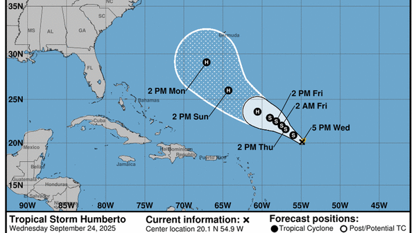
A new tropical storm, Humberto, has formed in the Atlantic, and it’s set to strengthen into a Category 2 hurricane over the next few days while following a track that keeps it out to sea.
The National Hurricane Center’s latest forecast for Humberto shows the system on a northern curving track that steers it clear of most of the Caribbean, except potentially Bermuda, and into the open Atlantic for most of its life.
As of the 5 p.m. update, it had maximum sustained winds of 40 mph. Forecasters said they expect the tropical storm to strengthen into a hurricane as soon as Sunday.
But it’s the other system in the Atlantic, the one to the west of Humberto, that’s most worth watching for Floridians. Michael Brennan, director of the National Hurricane Center, said in a video update Wednesday afternoon that Floridians, Bahamians and others along the Southeast coast should keep an eye on the forecast.
“Pay attention over the next several days as the systems evolve,” he said.
The hurricane center expects it to develop into a tropical depression around Friday or the weekend while it’s over the Bahamas. It could be close enough to Florida to potentially send impacts like rain or rough swells to the state.
As of 2 p.m. Wednesday, the hurricane center gave the westernmost wave a 30% chance of development in the next two days and an 80% shot at forming a tropical depression in the next seven days.
Forecasters say determining the future of the two systems is a tricky forecast. They could form close enough to impact each other, either weakening or strengthening the other.
READ MORE:Dueling tropical systems could see ‘Fujiwhara effect.’ What does that mean for Florida?
“The complexity here is that these systems are likely to interact with each other,” Brennan said in the video update.
For now, most of the other early models continued to suggest that both will develop and follow somewhat parallel lines along the Southeastern coast of the U.S.
It’s too soon to know what path the storm could take, because this early in the process, it doesn’t have a defined center swirl, and long-range “spaghetti” models aren’t as skilled as predicting storm paths without an eye to lock in on.
The next name on the list is Imelda.
_____
©2025 Miami Herald. Visit miamiherald.com. Distributed by Tribune Content Agency, LLC.


Comments