Florida coast to feel effects from Tropical Storm Imelda
Published in Weather News
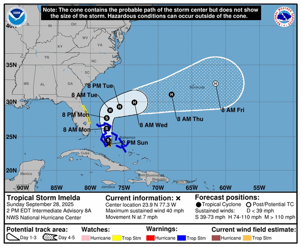
Tropical Storm Imelda formed on Sunday afternoon and will bring deteriorating conditions along Florida’s coast as the system moves over the Bahamas, according to the National Hurricane Center.
A tropical storm watch remains in effect along Florida’s east coast from the Palm Beach/Martin county line north to the Flagler/Volusia county line.
As of the NHC’s 2 p.m. advisory, the center of Imelda was located about 95 miles west-northwest of the central Bahamas and about 370 miles south east of Cape Canaveral. It is moving north at 7 mph with maximum sustained winds of 40 mph.
“A faster motion to the north is expected later today and continuing through Monday,” forecasters said. “On the forecast track, the center of the system is expected to move across the central and northwestern Bahamas this afternoon and tonight and then turn east-northeastward, moving away from the southeastern U.S. by the middle part of this week.”
Outer bands from the system are expected to strafe the Florida coast and the Atlantic waters offshore are under a tropical storm warning, according to the National Weather Service in Melbourne.
“Rainfall accumulations of 1- 2 inches are forecast generally along the coast south of Cape Canaveral, with isolated higher totals possible,” NWS forecasters said. “Training or persistent bands of showers could cause minor flooding concerns, with much of the forecast area highlighted in a Marginal Risk for Excessive Rainfall by the Weather Prediction Center. Multiple rounds of gusty showers and a few storms will continue through tonight, as T.D. Nine parallels the coast.”
The winds will pick up during the day and grow to their strongest overnight.
“Wind gusts 20-25 mph this afternoon will build to up to 30 mph along the coast overnight, with locally higher gusts in any bands of showers,” forecasters said. “Be sure to secure any lose items, including holiday decorations, by this evening, as conditions will continue to deteriorate overnight.”
As the system makes its closest approach Monday, there is a 40% chance winds of up to 45 mph will hit the coast east of I-95 with gusts up to 30 mph more inland.
“Beach and boating conditions will be dangerous by early Monday morning. Seas building up to 8-12 ft over the nearshore waters will produce high surf and a very high risk for rip currents,” forecasters said.
A high surf advisory is expected Monday and likely to continue through at least the late part of the week.
Coastal flooding could also be a concern into mid-week with wave runups to the dunes and sea walls over multiple high tide cycles that could lead to beach erosion.
The NHC said 1-2 feet of surge could run from the Volusia/Flagler county line north to the South Santee River, South Carolina.
In its direct path are the Bahamas, and a tropical storm warning remains in place for the central Bahamas including Cat Island, the Exumas, Long Island, Rum Cay and San Salvador, and the northwestern Bahamas including Eleuthera, New Providence, the Abacos, Berry Islands, Andros Island and Grand Bahama Island.
“Interests elsewhere in the Bahamas and along the southeast coast of the United States from Florida to North Carolina should monitor the progress of this system,” NHC stated.
The system is forecast to drop from 6-12 inches of rain across the northwest Bahamas through Tuesday that could cause flash and urban flooding. It’s still dropping rain on eastern Cuba where mudslides remain a danger.
Another 2-4 inches with some areas getting up to 7 inches are forecast into Wednesday morning across portions of the coastal Carolinas as the storm moves north and intensifies. It brings the potential threat of U.S. coastal flash, urban and river flooding.
Storm surge in the Bahamas could raise water levels from 1-3 feet above ground level.
Swells from this system as well as distant Humberto will begin hitting the Bahamas and Florida this weekend and spread to the rest of the U.S. coast early next week. The swells could bring life-threatening surf and rip current conditions.
The five-day forecast has Bermuda also within the system’s path.
Farther out in the Atlantic, the season’s third hurricane had reached Category 5 status Saturday with 160 mph winds, the highest ranking on the Saffir-Simpson Wind Scale.
As of NHC’s 11 a.m. advisory Sunday, Humberto had dropped in intensity with maximum sustained winds of 150 mph, bringing it back down to Category 4. It was located about 535 miles south of Bermuda moving west-northwest at 13 mph.
“A gradual turn toward the northwest, and then north is expected over the next couple of days. By the middle of the week, Humberto is forecast to begin accelerating toward the east-northeast,” forecasters said. “Fluctuations in intensity are possible during the next day or so. Gradual weakening is expected after that, but Humberto is expected to remain a dangerous major hurricane for the next couple of days.”
Hurricane-force winds extend out 35 miles and tropical-storm-force out 140 miles from its center, but the NHC warned its wind field was expected to grow much wider in the coming days.
Its forecast path could bring it near Bermuda and tropical storm watches may be issued later Sunday.
The two other hurricanes this season have been Erin and Gabrielle, both reaching major hurricane status.
The National Oceanic and Atmospheric Administration in early August updated its season forecast to call for 13-18 named storms, of which five to nine would grow into hurricanes. Two to five of those would develop into major hurricanes of Category 3 or higher.
Hurricane season runs from June 1 to Nov. 30.
_____
©2025 Orlando Sentinel. Visit orlandosentinel.com. Distributed by Tribune Content Agency, LLC.


Comments